
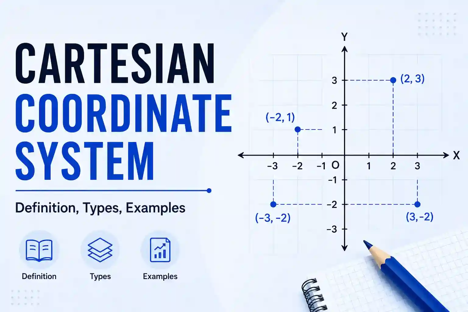
A Cartesian coordinate system is a way to specify the exact position of a point using perpendicular reference lines called axes. René Descartes, a French mathematician and philosopher, laid the foundation of this idea.
We extend the system into different dimensions depending on how many numbers we need to locate a point. The most common are the one-dimensional system (number line), the two-dimensional system (coordinate plane), and the three-dimensional system (space with length, width, and height).
In general, we can extend Cartesian coordinates to n-dimensional systems
In this article, we will explore the Cartesian coordinate system, its different types with examples, and briefly understand how to determine the distance between two points.
What is a Cartesian Coordinate System?
In coordinate geometry, a Cartesian coordinate system is a system of specifying the exact location of a point using perpendicular number lines (or axes).
In simple terms, a system uses one or more lines that remain perpendicular to each other (in case of two or more) and places numbers at equal intervals on those lines. We use this setup to locate a point on a number line, in a place or space.
Another name for the Cartesian coordinate system is the rectangular coordinate system.
In this coordinate system, each point is identified by a unique set of numbers, known as coordinates. Each number or coordinate shows its distance from the origin along each axis. Where all these distances intersect is the exact location of the point.
Since the Cartesian coordinate system is a system, it follows a structured approach with specific rules, conventions, and components used to locate a point.
General rules and conventions:
The Cartesian coordinate system follows a set of basic rules and conventions to represent points accurately on a plane or in space.
- The reference lines (axes) should be perpendicular to one another and intersect at a point called the origin (0,0).
- The coordinates used to describe the position of points are real numbers.
- The system follows a fixed order to locate a point. In a two-dimensional system, it writes the x-coordinate first to show the horizontal position and then adds the y-coordinate for the vertical position, forming (x, y).
In three-dimensional space, the system adds the z-coordinate after x and y and forms an ordered triplet like (x, y, z). - From the origin, the system assigns positive numbers to one side of a reference line and negative numbers to the other side. So that we can tell which direction a point lies in and describe its position clearly.
- In the standard system, each interval between two consecutive points on an axis should have the same distance.
Components of the Cartesian Coordinate System:
Origin: The point where all the perpendicular axes intersect with each other is the origin. The coordinates of this point are (0,0).
Axes: Axes are the reference lines that are used to locate a point. They are also known as coordinate lines, coordinate axes, and Cartesian axes.
Scale: A scale is used to draw equal intervals on each reference line.
Coordinates: Coordinates are numbers that describe the position of a point. For example, if the location of a point is (2, 3), then its coordinates are 2 and 3, which show its exact location using the x-axis and y-axis, respectively.
Regions: In the Cartesian coordinate system, space is divided into different sections. In one dimension, the number line is divided into positive and negative directions. For two dimensions, the plane is divided into 4 sections known as quadrants. In three dimensions, the space is divided into 8 sections known as octants.
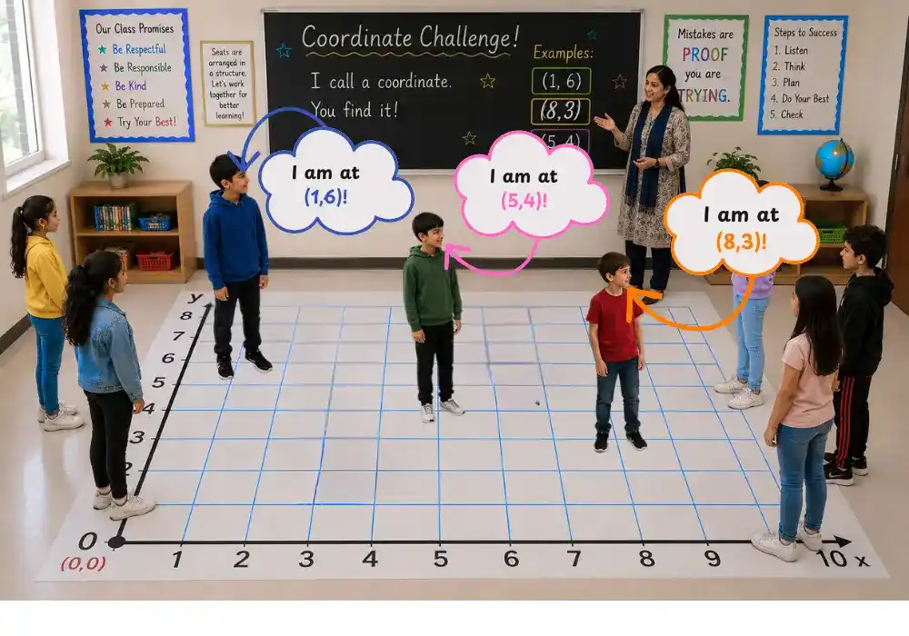
Example:
The coordinate system below gives an example of a Cartesian coordinate system.
In this example, the teacher made the Cartesian system on the classroom floor and asked students to locate and stand at coordinates (1,6), (8,3), and (5,4).
Types of the Cartesian Coordinate System
Even though the Cartesian coordinate system can be n-dimensional. But we generally define three types of Cartesian coordinate systems based on dimensions or the number of coordinates needed to locate a point.
- 1D Cartesian coordinate system
- 2D Cartesian coordinate system
- 3D Cartesian coordinate system
1) 1D Cartesian Coordinate System
A 1D Cartesian coordinate system is a single straight number line used to locate the position of a point from the origin.
On the straight line, numbers are marked at equal intervals. By convention, numbers to the right (or upward, depending on orientation) of the origin are positive, while numbers on the opposite sides are negative.
How to locate a point:
- Start from the origin 0.
- If the coordinate is positive, move to the right from the origin. If it is negative, move to the left from the origin.
- Move one unit at a time to the right or left from the origin, like 1,2,3,….
- Stop when you reach the required number, and mark the point
Every point in this system is described using only one number called a coordinate (for example, -3, 0, 5).
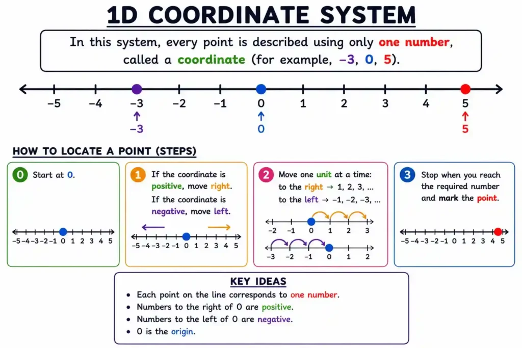
So, instead of using (x, y) or (x, y, z), a 1D system uses only x because movement is possible in only one direction along a straight line.
2) 2D Cartesian Coordinate System
A 2D Cartesian coordinate system is a system for locating points on a flat surface (a plane) using two perpendicular number lines that intersect at the origin.
Another name for the 2D Cartesian coordinate system is the xy coordinate system.
The flat surface formed by all possible points in this system is called the Cartesian plane (or coordinate plane).
In this system, we find or plot a point using an ordered pair (x,y), x coming first and y later.
By convention, we take the horizontal line as the x-axis, and a vertical line as the y-axis. The point where both number lines intersect is the origin (0,0). Numbers on the axis remain equally spaced, and the gap between consecutive numbers forms a unit.
By convention, the points on the right (and up) side of the number lines are positive. The points on the left (and down) side of the number lines are negative. An ordered pair (x,y), x coming first and y later.
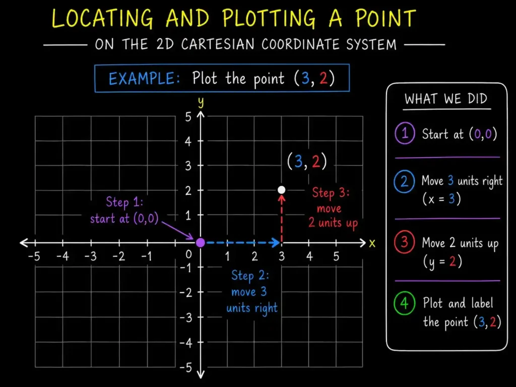
How to plot a point in a 2D Cartesian coordinate system
- Identify what coordinates to plot on the Cartesian plane
- Start from the origin (0,0)
- Move x-units right if the x-coordinate of a point is positive and left if it is negative
- And then from there, move the y-unit up if the y-coordinate is positive and down if the y-coordinate is negative
- Stop when you reach the required coordinates and mark the point with its coordinates.
The figure below shows the process of plotting the point (3,2) in the 2D Cartesian system.
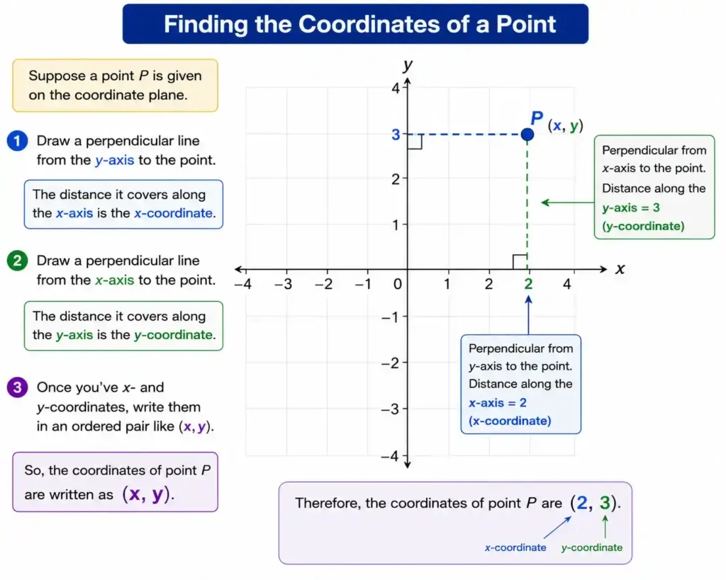
If someone gives you a point in the 2D Cartesian coordinate system and asks for its coordinates,
- Draw a perpendicular line from the y-axis to the point. The distance it covers along the x-axis is the x-coordinate.
- Similarly, draw a perpendicular line from the x-axis to the point. The distance it covers along the y-axis is the y-coordinate.
- Once you have x- and y-coordinates, write them in an ordered pair like (x,y)
The figure below shows visually how to find the coordinates of a point
3D Cartesian Coordinate System
The 3D Cartesian coordinate system is an extension of the 2D Cartesian system used to locate a point in space with the help of three mutually perpendicular axes that meet at a common point called the origin.
Another name for a 3D Cartesian coordinate system is the xyz coordinate system.
In this system, we find or plot a point with an ordered triplet (x,y,z). The coordinate order would be x, then y, and then z.
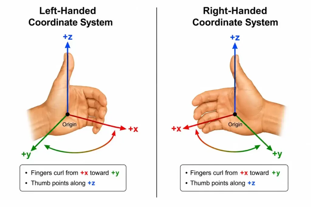
The common type of 3D Cartesian coordinate system that we use in physics and math is the right-handed Cartesian coordinate system.
In this type, you point your right-hand thumb along the +z-axis, and when you curl your fingers, they move from the +x-axis toward the +y-axis. This curl appears counterclockwise when viewed from the positive z direction.
In a left-handed coordinate system, the relationship is reversed. If you point your left-hand thumb along the +z-axis, your fingers curl from the +x-axis toward the +y-axis in a clockwise direction when viewed from the positive z direction.
The image below visually shows this concept to help you understand it better
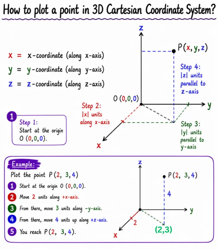
How to plot a point in a 3D Cartesian coordinate system?
1) Start at the origin 0 (0,0,0).
2) Move |x| units along the x-axis.
If x>0, move in the positive x-direction.
If x <0, move in the negative x-direction.
3) From that point, move |y| units parallel to the y-axis.
If y> 0, move in the positive y-direction.
If y<0, move in the negative y-direction.
4) From that point, move |z| units parallel to the z-axis.
If z>0, move up (positive z-direction).
If z <0, move down (negative z-direction).
5) You will reach the point P(x, y, z).
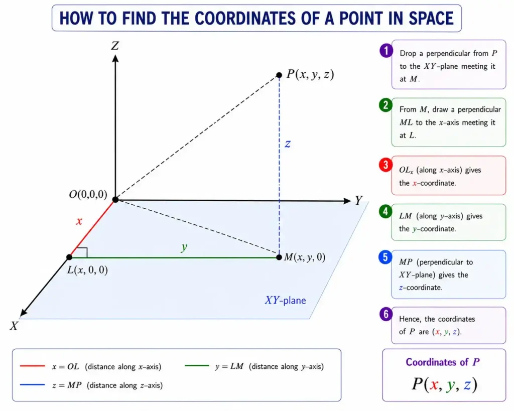
How to find the coordinates of a point in a 3D Cartesian coordinate system?
To find the coordinates of a point P(x,y,z):
- Draw a perpendicular from P to the xy-plane. Let it meet the plane at point M. This point represents (x,y,0)
- From M, draw a perpendicular ML to the x-axis, meeting the x-axis at L.
- The distance OL (from the origin O to L along the x-axis) is the x-coordinate.
- The distance LM is parallel to the y-axis and represents the y-coordinate.
- The distance MP is the z-coordinate.
- By calculating these distances, we get the coordinates of point P (x,y,z).
Rotated or Tilted Coordinate System
The Cartesian coordinate system doesn’t need to be fully horizontal or vertical. You can rotate or tilt it to simplify the problem.
For example, a skier sliding down a slope.
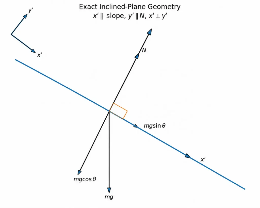
Instead of using normal x (horizontal) and y (vertical), we tilt the axes:
- x-axis: along the slope
- y-axis: perpendicular to the slope
Why?
Because then motion happens only in the x-direction and the acceleration in the y-direction becomes zero. Only gravity requires splitting into components.
If we use standard Cartesian axes (x, y), gravity stays simple, and the normal force splits into components.
∑Fx = N sinθ = max
∑Fy = N cosθ – mg = may
This creates two coupled equations, plus a geometric constraint since motion follows the incline (ax/ay = – tanθ).
With inclined axes (x′, y′), everything aligns with motion:
∑Fx′ = mg sinθ = ma
∑Fy′ = N – mg cosθ = 0
Now the equations become decoupled and directly usable.
Representing a Vector in the Cartesian Coordinate System
When we talk about a vector in the Cartesian coordinate system, we are basically describing how the vector lies on a standard x and y grid (and z in three dimensions). Normally, we write the vector as
r = 3i + 5j + 6k,
where i, j, and k are unit vectors along the x-axis, y-axis, and z-axis, respectively.
The numbers 3, 5, and 6 represent the components of the vector along the x, y, and z axes. This means that, beginning at the origin, the vector moves 3 units in the direction of the x-axis, then 5 units in the direction of the y-axis, and finally 6 units along the z-axis, defining its position in three-dimensional space.
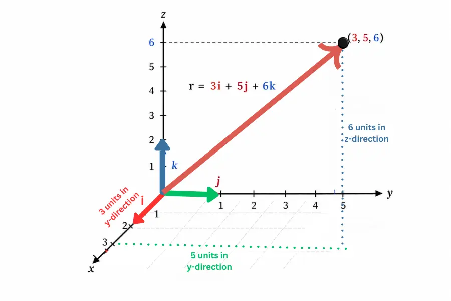
The Cartesian coordinate system is useful because it gives a clear visual structure. Instead of dealing with abstract directions, it places everything on a simple Cartesian system and lets users plot and measure positions and movements easily. This is why vectors and the Cartesian coordinate system connect so closely in geometry and physics.