
Imagine you are trying to describe the exact location of an object on a floor. You might say, “a little to the right, then go straight a bit,” which is vague. To remove this ambiguity, we use a coordinate system, which provides a precise way to describe positions using numbers.
We use different types of coordinate systems depending on the nature of the problem. By choosing a system that matches the geometry of the problem, many variables become constant or irrelevant, which simplifies the equations and makes the problem easier to solve.
This article explores the concept of a coordinate system, explains its various types, and helps you understand how to select the most suitable one for your problem.
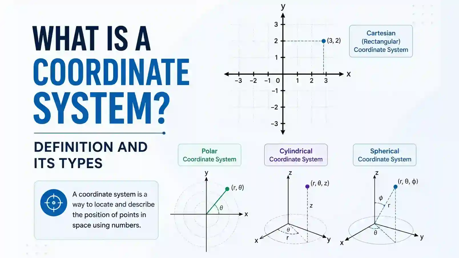
What is a Coordinate System Definition?
A coordinate system is a system used to uniquely describe the position of a point by using one or more numbers in space.
Here, “system” means a set (collection) of rules and components that work together to describe the position of a point. And the numbers that describe the position of a point are called coordinates.
For example, in a Cartesian coordinate system, the rules are
- x-, y-, and z-axes are perpendicular and intersect at a point called the origin.
- The system uses a uniform scale, meaning consecutive intervals on an axis represent equal distances.
- When writing coordinates, the first value represents the x-axis position and the second value represents the y-axis position, written as (x,y).
And, the components of it are
- reference lines (or axis)
- origin
- scale (how the distance between two consecutive points is measured)
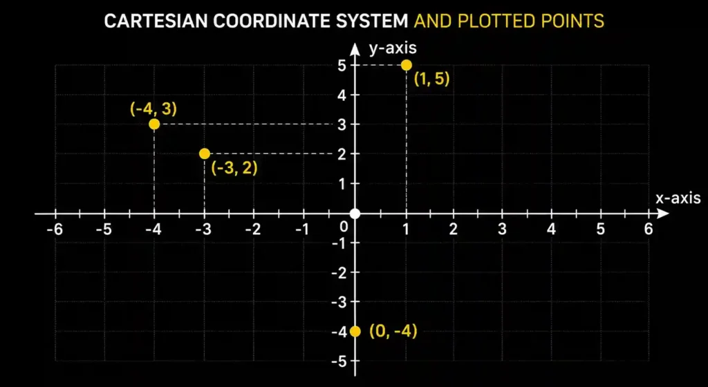
Visual example of a coordinate system: The image clearly illustrates how different points are precisely located in the Cartesian plane using numbers. Each point is defined by a unique pair of coordinates (x,y), which identifies its exact position on the plane. No two distinct points share the same set of coordinates.
What are the Different Types of Coordinate Systems in Physics?
There are four different types of coordinate systems that we use in physics. Those are
- Cartesian Coordinate System
- Polar Coordinate System
- Cylindrical Coordinate System
- Spherical Coordinate System
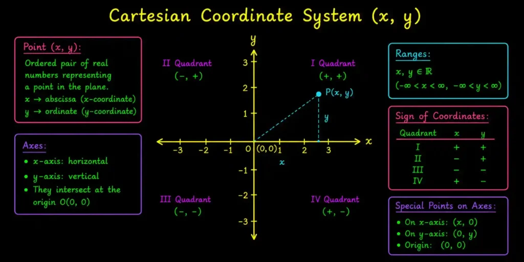
1) What is the Cartesian Coordinate System?
In basic mathematics, a Cartesian coordinate system is a type of coordinate system that locates a point in space using one or more axes, which are perpendicular in case of two or more, and intersect at a point called the origin.
The order of writing Cartesian coordinates is (x, y, z).
Another name for the Cartesian coordinate system is the rectangular coordinate system.
To visualize it, we draw perpendicular lines that meet at a common point known as the origin. For example,
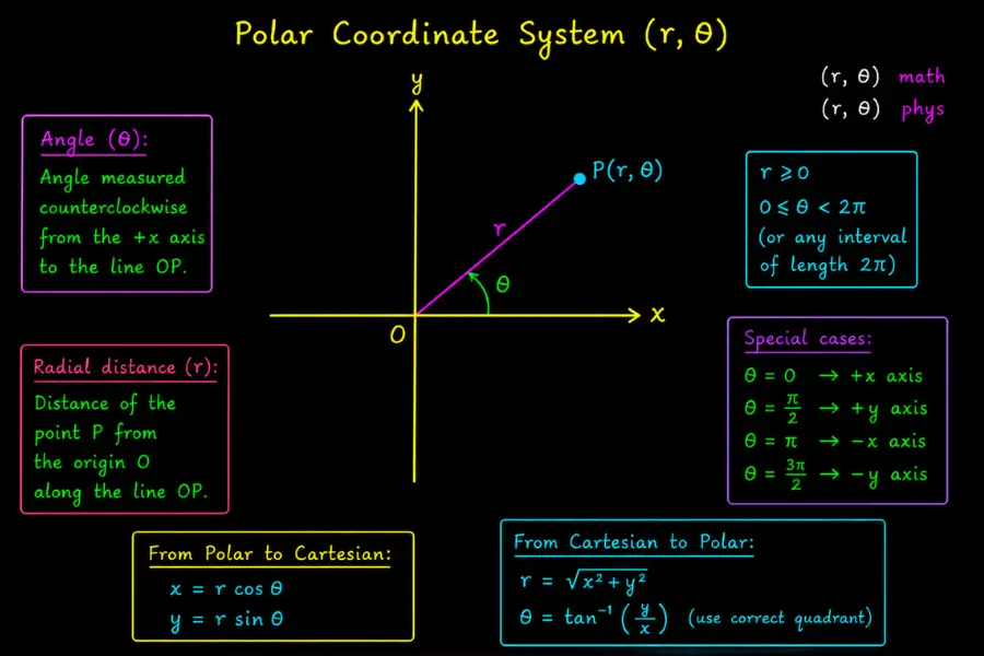
2) What is the Polar Coordinate System?
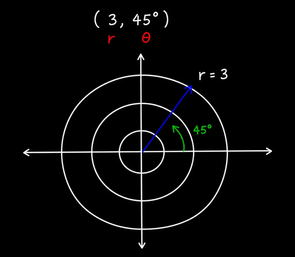
The polar coordinate system is a two-dimensional coordinate system that locates a point using coordinates
- r (it shows how far the point is from the center (origin)) and
- 𝜃 (tells the angle you move in a counterclockwise direction starting from the positive x-axis to reach that point).
The order of writing polar coordinates is (r,θ). Normally, we define the ranges of polar coordinates as:
r ≥ 0
θ ∈ [0,2π)
The example in the image clearly explains this definition
r and 𝜃 could also be taken as both positive and negative. In this case, if
- r > 0: the point lies in the direction of θ at the distance |r|
- r < 0: same distance |r|, but opposite direction along the same line. Add π to angle θ to define the exact direction, i.e., (-r,θ) = (r,θ+π)
- θ < 0: Measure the angle clockwise instead of counterclockwise from the +x-axis.
The relation between Cartesian and polar coordinates is
r=√x2+y2
θ = tan-1(y/x)
x = r cosθ
y = r sinθ
So, if you know the Cartesian coordinates, you can find the polar coordinates. If you know the polar coordinates, you can find the Cartesian coordinates.
We extend the idea of polar coordinates into 3-dimensions with the help of spherical and cylindrical coordinate systems.
3) What is the Spherical coordinate system?
Spherical coordinate system is a 3-dimensional system that defines the position of a point using a radial distance and two angles: polar angle θ and azimuthal angle ϕ.
It is also known as the spherical polar coordinate system.
In mathematics, the order to write spherical coordinates is (r, ϕ, θ), and in physics it is written as (r, θ, ϕ). The symbol ρ (rho) is also used in place of the symbol r.
The image below shows how to find the coordinates of a point in a spherical coordinate system, or if you have coordinates, how to draw a point
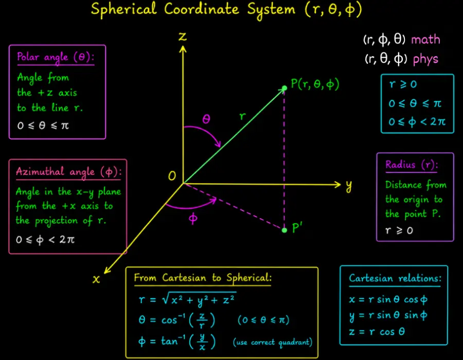
The relations between Cartesian and spherical coordinates are
r = √x2+y2+z2
θ = cos-1 (z/r)
ϕ = tan-1 (y/x)
x = r sinθcosϕ
y = r sinθsinϕ
z = rcosθ
4) What is the Cylindrical Coordinate System?
A cylindrical coordinate system is a 3-dimensional system that represents the position of a point using the distance of its projection onto the xy-plane from the origin, the angle that this projection makes with the positive x-axis, and the height of the point above the xy-plane.
The order to write these coordinates is (r,θ,z). It is also known as a cylindrical polar or polar cylindrical coordinate system.
Let’s see it visually to understand it better
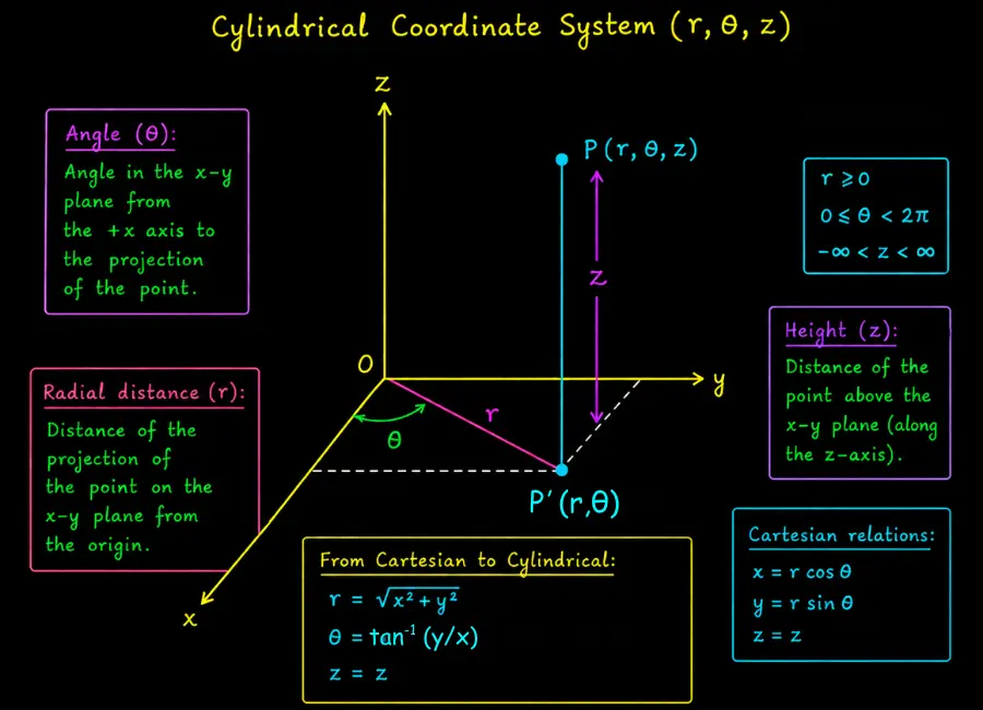
The relations between Cartesian and cylindrical coordinates are
r = √x2+ y2
θ = tan-1 (y/x)
z = z
x = r cosθ
y = r sinθ
z = z
More precisely, polar, spherical, and cylindrical coordinate systems are types of curvilinear coordinate systems because some of their coordinate lines are curved. For example, the coordinate lines of the polar coordinate system consist of circles centered at the origin (for constant r) and straight radial lines (for constant θ), as shown in the figure
So instead of forming a rectangular grid like Cartesian coordinates, the polar system forms a circular grid, where a point is located by its radial distance from the origin and its angular direction measured from a fixed reference axis.
How to Choose the Right Coordinate System for a Physics Problem?
When solving a physics problem that involves a coordinate system, one of the smartest decisions you can make is choosing the right one.
This choice does not change the physics, but it can completely change how easy or difficult the math becomes. In fact, the same problem can look simple in one system and very complicated in another.
So, choose the coordinate system that makes the problem easiest to solve.
Here is a step-by-step procedure to choose:
Step 1: Look at the geometry of the problem
Start by asking: What is the shape or structure of the problem?
- If everything is aligned along straight, perpendicular directions, Cartesian coordinates (x, y, z) are usually the best choice
- If motion is around a central point in a plane, use Polar coordinates (r, θ)
- If the system extends around an axis in 3D, use Cylindrical coordinates (r, θ, z)
- If everything spreads outward from a point in all directions, use Spherical coordinates (r, θ, φ)
Step 2: Look for Constraints (or Restrictions)
Check if the system has conditions like:
- Fixed distance from a point
- Motion restricted to a surface
- Symmetry around a line or point
If such constraints exist, choose a coordinate system that already includes them naturally, instead of forcing them through equations.
Step 3: Look at the Direction of Forces
Physics is driven by forces, so this is a powerful clue.
- If forces act in fixed directions (like gravity downward), Cartesian works well
- If forces point toward/away from a center, a polar or spherical system is better
- If force points outward from an axis, use Cylindrical
Step 4: Choose the System That Simplifies the Work
Sometimes multiple coordinate systems can work. In that case, choose the one that:
- Reduces the number of variables
- Removes unnecessary components
- Avoids complicated trigonometry
- Turns a 3D problem into simpler parts
These steps provide you with a clear roadmap for selecting a coordinate system.
However, the final choice also depends on physical intuition and experience. Always analyze the structure of the problem to decide which coordinate system simplifies the mathematics and best matches the physical situation.